geo数据结构geolocation,地理坐标。
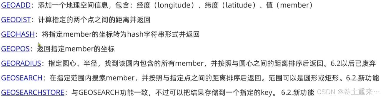
存储地理坐标信息
根据经纬度检索数据。

bash
[root@localhost ~]# redis-cli
127.0.0.1:6379> geoadd g1 116.378248 39.865275 bjn 116.42803 39.903738 bjz 116.322287 39.893729 bjx
(integer) 3
127.0.0.1:6379>
获取北京南到北京西的距离,默认单位为米,指定单位km为千米。
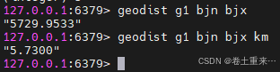
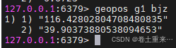
返回北京站的坐标
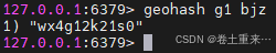
返回北京站坐标的hash值

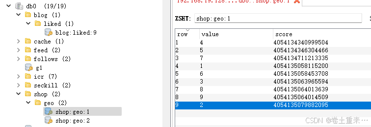
score存的是店铺经纬度坐标。这里的值可以代表和转化为真正的经纬度。
key 存入店铺类型type id,将同类型的数据放到一起。
value存入店铺的id.
修改pom文件
java
<!--redis springDataRedis2.3.9 并不支持redis6.2提供的GEOSearch命令,因此需要修改pom文件-->
        <dependency>
            <groupId>org.springframework.boot</groupId>
            <artifactId>spring-boot-starter-data-redis</artifactId>
            <exclusions>
                <exclusion>
                    <groupId>org.springframework.data</groupId>
                    <artifactId>spring-data-redis</artifactId>
                </exclusion>
                <exclusion>
                    <artifactId>lettuce-core</artifactId>
                    <groupId>io.lettuce</groupId>
                </exclusion>
            </exclusions>
        </dependency>

        <dependency>
            <groupId>org.springframework.data</groupId>
            <artifactId>spring-data-redis</artifactId>
            <version>2.6.2</version>
        </dependency>

        <dependency>
            <artifactId>lettuce-core</artifactId>
            <groupId>io.lettuce</groupId>
            <version>6.1.6.RELEASE</version>
        </dependency>
向redis中添加数据
java
 @Test
    public void loadShopData() {
        //1.查询店铺信息
        List<Shop> shops = shopService.list();
        //2.按照店铺类型分组,typeId一致的放入一个集合
        Map<Long, List<Shop>> typeIdShops = shops.stream().collect(Collectors.groupingBy(Shop::getTypeId));
        //3.分批完成写入redis
        for (Map.Entry<Long, List<Shop>> entry : typeIdShops.entrySet()) {
            Long typeId = entry.getKey();
            String key = "shop:geo:" + typeId;
            List<Shop> shopList = entry.getValue();
            List<RedisGeoCommands.GeoLocation<String>> stringGeoLocation = new ArrayList<>(typeIdShops.size());
            //写入redis geoadd key jd wd member
            for (Shop shop : shopList) {
                //一个一个添加
//                stringRedisTemplate.opsForGeo().add(key,
//                        new Point(shop.getY(), shop.getX()),
//                        shop.getId().toString());
                //批量组装数据
                RedisGeoCommands.GeoLocation<String> geoLocation =
                        new RedisGeoCommands.GeoLocation<>(shop.getId().toString(),
                                new Point(shop.getY(), shop.getX()));
                stringGeoLocation.add(geoLocation);
            }
            //批量写入redis
            stringRedisTemplate.opsForGeo().add(key, stringGeoLocation);
        }

    }
java
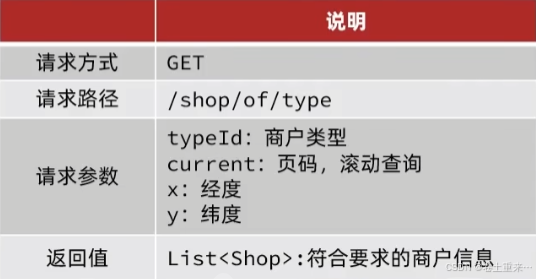
 @GetMapping("/of/type")
    public ApiResponse queryShopByType(@RequestParam("typeId") Integer typeId,
                                       @RequestParam(value = "current", defaultValue = "1") Integer current,
                                       @RequestParam(value = "x", required = false) Double x,
                                       @RequestParam(value = "y", required = false) Double y
                                       ) {
        List<Shop> shops = shopService.queryShopByType(typeId, current, x, y);
        return ApiResponse.success(shops);
    }
java
@Override
public List<Shop> queryShopByType(Integer typeId, Integer current, Double x, Double y) {
int pageSize = 5;
//1.判断是否需要根据坐标查询
if(x == null || y == null) {
Page<Shop> page = query().eq("type_id", typeId).page(new Page<>(current, pageSize));
return page.getRecords();
}
//2.计算分页参数
int from = (current -1) * pageSize;
int end = current * pageSize;
//3.查询redis,按照距离排序、分页。结果:shopId,distance
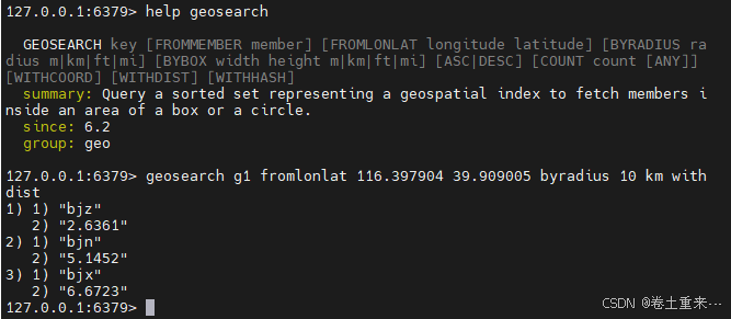
// geosearch key fromlonlat x y byradius 10 km with dist
String key = "shop:geo:" + typeId;
GeoResults<RedisGeoCommands.GeoLocation<String>> results = stringRedisTemplate.opsForGeo().search(key,
GeoReference.fromCoordinate(x, y),
//默认单位米,寻找五千米范围内的店铺
new Distance(5000),
//返回包含距离
RedisGeoCommands.GeoSearchCommandArgs.newGeoSearchArgs().includeDistance()
//默认从地0-end条的数据记录
.limit(end));
//4.解析出id
if(results == null) {
return new ArrayList<>();
}
List<GeoResult<RedisGeoCommands.GeoLocation<String>>> content = results.getContent();
if(content.size() <= from) {
//说明没有下一页了,直接返回空集合
return new ArrayList<>();
}
//截取从from-end部分的数据
List<Long> ids = new ArrayList<>(content.size());
Map<String, Distance> distanceMap = new HashMap<>(content.size());
content.stream().skip(from).forEach(e -> {
//member值,店铺id
String shopIdStr = e.getContent().getName();
ids.add(Long.valueOf(shopIdStr));
//获取距离
Distance distance = e.getDistance();
distanceMap.put(shopIdStr, distance);
});
//5.根据id查询shop
String idStr = StrUtil.join(",", ids);
List<Shop> shopList = query().in("id", ids).last("order by field (id," + idStr + ")").list();
//6.返回shop集合
shopList.stream().forEach(e -> e.setDistance(distanceMap.get(e.getId().toString()).getValue()));
return shopList;
}