一、最终效果
🎯 实现功能
-
点击地图上的多边形(Feature)
-
列表自动滚动到对应位置
-
当前项高亮显示
-
鼠标悬浮 Feature 变为 pointer
👉 核心体验:地图 → 列表联动
二、前言
在 WebGIS 项目中,经常会遇到这样一个需求:
👉 点击地图上的某个要素(Feature)
👉 右侧列表自动滚动并定位到对应数据项
这个交互在以下场景非常常见:
-
无人机巡检系统 ✈️
-
电子围栏管理 🗺️
-
设备点位管理系统 📍
-
GIS 可视化大屏
本篇文章带你用 Vue3 + OpenLayers 实现一个完整、丝滑的联动效果。
三、核心实现思路
整个功能其实就三步:
1️⃣ Feature 和列表建立索引关系
new Feature({
  geometry: item.area,
  listindex: i,
  name: item.descName,
});
👉 关键点:
给每个 Feature 绑定 listindex
2️⃣ 点击地图获取 Feature
const feature = map.value.forEachFeatureAtPixel(
  e.pixel,
  (feature) => feature
);
👉 OpenLayers 核心 API
3️⃣ 滚动到对应 DOM
const el = document.getElementById("pos" + i);
el && el.scrollIntoView({ behavior: "smooth", block: "center" });
🔥 重点:
比 window.location.hash 更优雅!
四、完整代码实现
javascript
<!--
* @Author: 彭麒
* @Date: 2026/3/19
* @Email: 1062470959@qq.com
* @Description: 此源码版权归吉檀迦俐所有,可供学习和借鉴或商用。
-->
<template>
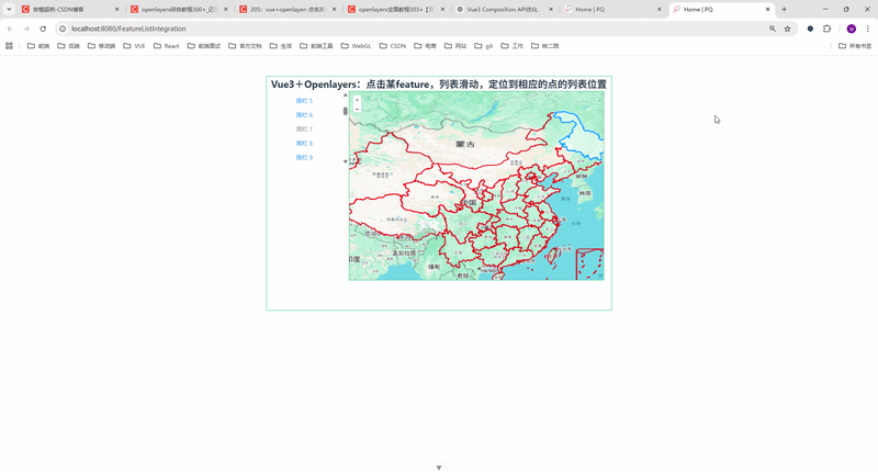
<div class="container">
<div class="w-full flex justify-center flex-wrap">
<div class="font-bold text-[24px]">
Vue3+Openlayers:点击某feature,列表滑动,定位到相应的点的列表位置
</div>
</div>
<div class="list">
<div
v-for="(item, index) in list"
:key="index"
:id="'pos' + index"
style="margin: 10px 10px 0;"
>
<el-link :type="item.show ? 'primary' : 'info'">
{{ item.descName }}
</el-link>
</div>
</div>
<div id="vue-openlayers"></div>
</div>
</template>
<script setup>
import { ref, onMounted } from "vue";
import "ol/ol.css";
import { Map, View } from "ol";
import TileLayer from "ol/layer/Tile";
import VectorLayer from "ol/layer/Vector";
import VectorSource from "ol/source/Vector";
import XYZ from "ol/source/XYZ";
import Feature from "ol/Feature";
import { Style, Fill, Stroke } from "ol/style";
import { Select } from "ol/interaction";
import GeoJSON from "ol/format/GeoJSON";
import fData from "@/assets/map/china.json";
const map = ref(null);
const source = new VectorSource({ wrapX: false });
const select = ref(null);
const list = ref([]);
const drawfeatures = ref([]);
const initload = () => {
drawfeatures.value = new GeoJSON().readFeatures(fData, {
dataProjection: "EPSG:4326",
featureProjection: "EPSG:4326",
});
updateList();
showPolygons();
};
// 更新列表
const updateList = () => {
list.value = [];
drawfeatures.value.forEach((feature, index) => {
const g = feature.getGeometry();
list.value.push({
descName: "围栏 " + index,
show: true,
area: g,
});
});
};
// 显示多边形
const showPolygons = () => {
const features = list.value.map((item, i) => {
return new Feature({
geometry: item.area,
listindex: i,
name: item.descName,
});
});
source.addFeatures(features);
};
// 点击 feature → 滚动列表
const clickFeature = () => {
map.value.on("click", (e) => {
const feature = map.value.forEachFeatureAtPixel(
e.pixel,
(feature) => feature
);
// 鼠标样式
map.value.getTargetElement().style.cursor = feature
? "pointer"
: "auto";
if (feature) {
const i = feature.get("listindex");
// 滚动定位(推荐替代 hash)
const el = document.getElementById("pos" + i);
el && el.scrollIntoView({ behavior: "smooth", block: "center" });
list.value.forEach((item, index) => {
item.show = index !== i;
});
} else {
list.value.forEach((item) => (item.show = true));
}
});
};
// 初始化地图
const initMap = () => {
const iconStyle = new Style({
stroke: new Stroke({
color: "red",
width: 2,
}),
fill: new Fill({
color: "rgba(255,0,0,0)",
}),
});
const googleLayer = new TileLayer({
source: new XYZ({
url: "https://www.google.com/maps/vt?lyrs=m&gl=en&x={x}&y={y}&z={z}",
crossOrigin: "anonymous",
}),
});
const drawLayer = new VectorLayer({
source,
style: iconStyle,
});
map.value = new Map({
target: "vue-openlayers",
layers: [googleLayer, drawLayer],
view: new View({
projection: "EPSG:4326",
center: [110.4116821, 41.7966156],
zoom: 3,
}),
});
clickFeature();
select.value = new Select();
map.value.addInteraction(select.value);
};
onMounted(() => {
initMap();
initload();
});
</script>
<style scoped>
.container {
width: 840px;
height: 570px;
margin: 50px auto;
border: 1px solid #42B983;
}
#vue-openlayers {
width: 620px;
height: 460px;
margin: 0 auto;
border: 1px solid #42B983;
float: left;
}
.list {
width: 200px;
height: 180px;
margin: 0 auto;
float: left;
overflow-y: auto;
}
</style>五、关键优化点(面试加分项🔥)
✅ 1. scrollIntoView 优于 hash
❌ 不推荐:
window.location.hash = "#pos" + i;✅ 推荐:
el.scrollIntoView({ behavior: "smooth" });✅ 2. 数据驱动 UI
item.show = index !== i;👉 Vue 响应式自动更新 UI
✅ 3. Feature 绑定业务数据
feature.get("listindex")👉 地图 → 业务数据的桥梁
✅ 4. 解耦设计(高级)
可以进一步抽成:
-
useMap()
-
useFeatureClick()
-
useListSync()
👉 适合大型项目
六、可扩展功能(建议你写进简历)
🔥 你可以继续升级:
-
点击列表 → 地图定位(反向联动)
-
Feature 高亮选中(改变样式)
-
hover 提示
-
海量数据优化(WebGL / 分层加载)
-
地图聚合 / 分组展示
七、总结
本文实现了一个非常实用的 GIS 交互功能:
✅ 地图点击
✅ 列表联动
✅ 平滑滚动定位
✅ Vue3 响应式驱动
👉 核心一句话总结:
"通过 Feature 绑定索引,实现地图与列表的双向映射"