如何在cesium的地图上添加geojson数据,并计算中心点,在中心点打上图标和文字
效果图: 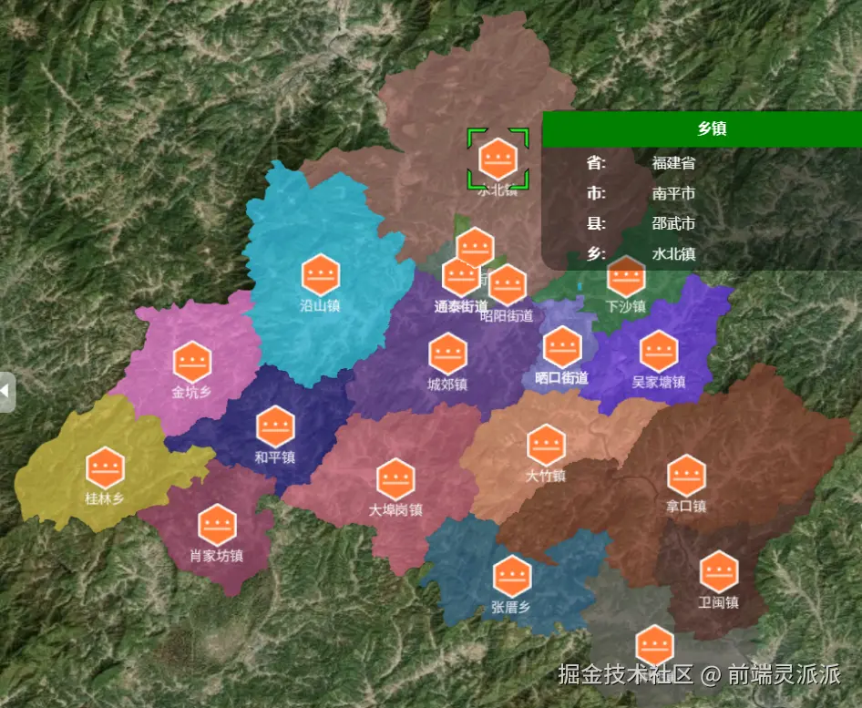
一、创建地图
js
import * as Cesium from "cesium";
Cesium.Ion.defaultAccessToken = key;
const viewer = new Cesium.Viewer(id);
二、加载geojson数据
使用Cesium.GeoJsonDataSource.load(file,option)加载geojson文件、或者是geojson的数据,遍历每个区域使用viewer.entities.add()用于添加中心点的图标。使用viewer.entities.remove(entity)可以移除实体。
js
let lastAddedDataSource = null
let center = []
const dataSourcePromise = Cesium.GeoJsonDataSource.load(geoJsonObject, {
    // 可选参数
    clampToGround: true, // 使数据贴合地形
    stroke: Cesium.Color.HOTPINK,
    // fill: Cesium.Color.GREEN.withAlpha(0.5),
    strokeWidth: 3,
  });

  dataSourcePromise
    .then(function (dataSource) {
      // 添加数据源到Viewer
      viewer.dataSources.add(dataSource);

      lastAddedDataSource = dataSource;

      // 获取所有实体
      const entities = dataSource.entities.values;;

      // 遍历每个实体
      for (let i = 0; i < entities.length; i++) {
        const entity = entities[i];

        // 读取properties信息
        const properties = entity.properties;

        //每个区域添加随机颜色
        entity.polygon.material = Cesium.Color.fromRandom({
            alpha: 0.7,
            minimumRed: 0.1,
            minimumGreen: 0.1,
            minimumBlue: 0.1,
          });

        //中心点
        const positions = entity.polygon.hierarchy.getValue(Cesium.JulianDate.now()).positions;

        // 计算中心点
        const centerPosition = computePolygonCentroid(positions);

          // 在中心点添加图标
          let point = viewer.entities.add({
            id: id,
            name: name,
            position: centerPosition,
            label: {
                text: properties?.NAME?._value,
                scale: 0.5,
                verticalOrigin: Cesium.VerticalOrigin.BOTTOM,
                pixelOffset: new Cesium.Cartesian2(0, 40),
            },
            billboard: {
              image: icon, // 图标路径
              width: 50,
              height: 50,
              verticalOrigin: Cesium.VerticalOrigin.TOP,
              disableDepthTestDistance: Number.POSITIVE_INFINITY, // 确保图标始终可见
              pixelOffset: new Cesium.Cartesian2(0, -25),
            },
            monitoItems:  {
                省: properties["省"]?._value,
                市: properties["市"]?._value,
                县: properties["县"]?._value,
            },
          });

          center.push(point);
      }

      // 自动缩放到数据范围
      viewer.zoomTo(dataSource);
    })
    .catch(function (error) {
      console.error("Error loading GeoJSON:", error);
    });
计算中心点的方法
js
function computePolygonCentroid(positions) {
    const cartographics = positions.map(p => Cesium.Cartographic.fromCartesian(p));

    // 转换为经纬度坐标
    const points = cartographics.map(c => {
        return {
            lon: Cesium.Math.toDegrees(c.longitude),
            lat: Cesium.Math.toDegrees(c.latitude)
        };
    });

    // 确保多边形是闭合的
    if (points.length > 0 &&
        (points[0].lon !== points[points.length-1].lon ||
         points[0].lat !== points[points.length-1].lat)) {
        points.push({...points[0]});
    }

    // 计算中心点
    let area = 0;
    let centroidLon = 0;
    let centroidLat = 0;

    for (let i = 0; i < points.length - 1; i++) {
        const p1 = points[i];
        const p2 = points[i + 1];

        const f = p1.lon * p2.lat - p2.lon * p1.lat;
        centroidLon += (p1.lon + p2.lon) * f;
        centroidLat += (p1.lat + p2.lat) * f;
        area += f;
    }

    area /= 2;
    centroidLon /= (6 * area);
    centroidLat /= (6 * area);

    // 转换回笛卡尔坐标
    return Cesium.Cartesian3.fromDegrees(centroidLon, centroidLat);
}
移除geojson数据
js
// 移除GeoJSON
 viewer.dataSources.remove(lastAddedDataSource)