3D曲面图是科学计算和工程可视化中常用的图表类型,它通过起伏的曲面展示二维数据的变化趋势。Qt Data Visualization 模块中的 Surface3D 类型提供了强大的曲面可视化能力。
Surface3D 核心属性与方法
表:Surface3D主要属性与方法
| 属性/方法 | 类型 | 描述 | 示例 |
|---|---|---|---|
width |
real | 曲面图宽度 | width: parent.width |
height |
real | 曲面图高度 | height: parent.height |
selectionMode |
enum | 选择模式(无/单项/行/列/行与列/切片) | AbstractGraph3D.SelectionItem |
shadowQuality |
enum | 阴影质量(无/低/中/高/软低/软中/软高) | AbstractGraph3D.ShadowQualityHigh |
scene.activeCamera |
Q3DCamera | 控制场景相机 | scene.activeCamera.xRotation: 60.0 |
theme |
Theme3D | 设置图表主题 | theme: Theme3D { type: Theme3D.ThemeArmyBlue } |
axisX |
Value3DAxis | X轴配置 | axisX: Value3DAxis { title: "经度"; min: -180; max: 180 } |
axisY |
Value3DAxis | Y轴配置 | axisY: Value3DAxis { title: "高度"; min: 0; max: 10000 } |
axisZ |
Value3DAxis | Z轴配置 | axisZ: Value3DAxis { title: "纬度"; min: -90; max: 90 } |
flipHorizontalGrid |
bool | 是否翻转水平网格 | flipHorizontalGrid: true |
surfaceSeries |
list | 曲面系列列表 | surfaceSeries: [heightMapSeries, temperatureSeries] |
addSeries() |
method | 添加曲面系列 | surface3D.addSeries(newSeries) |
removeSeries() |
method | 移除曲面系列 | surface3D.removeSeries(oldSeries) |
release() |
method | 释放资源 | Component.onDestruction: surface3D.release() |
基本曲面图实现
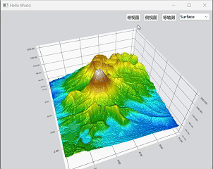
以下是一个完整的地形高度图示例,展示了如何使用Surface3D显示地理高程数据:
import QtQuick
import QtQuick.Controls
import QtDataVisualization

Window {
    width: 640
    height: 480
    visible: true
    title: qsTr("Hello World")

    Surface3D {
        id: surfaceGraph
        anchors.fill: parent
        theme: Theme3D { type: Theme3D.ThemeArmyBlue }

        // 设置坐标轴
        axisX: ValueAxis3D {
            title: "东西方向 (km)"
        }

        axisY: ValueAxis3D {
            title: "高度 (m)"
            min: 30
            max: 200
        }

        axisZ: ValueAxis3D {
            title: "南北方向 (km)"
        }

        // 添加曲面系列
        Surface3DSeries {
            id: terrainSeries
            itemLabelFormat: "(@xLabel km, @zLabel km): @yLabel m"
            drawMode: Surface3DSeries.DrawSurfaceAndWireframe
            flatShadingEnabled: false

            // 使用高度图数据代理
            HeightMapSurfaceDataProxy {
                id: heightMapProxy
                heightMapFile: ":/layer_1.png"
            }

            // 自定义渐变颜色
            baseGradient: ColorGradient {
                ColorGradientStop { position: 0.0; color: "#0000ff" }  // 深水区
                ColorGradientStop { position: 0.2; color: "#00ffff" }  // 浅水区
                ColorGradientStop { position: 0.25; color: "#00aa00" } // 海滩
                ColorGradientStop { position: 0.5; color: "#ffff00" }  // 平原
                ColorGradientStop { position: 0.75; color: "#aa5500" } // 山地
                ColorGradientStop { position: 1.0; color: "#ffffff" } // 雪山
            }

            // 网格线样式
            wireframeColor: "#555555"
        }

        // 相机初始位置
        scene.activeCamera.xRotation: 20.0
        scene.activeCamera.yRotation: 45.0
    }

    // 控制面板
    Row {
        anchors.top: parent.top
        anchors.right: parent.right
        spacing: 10
        padding: 10

        Button {
            text: "俯视图"
            onClicked: {
                surfaceGraph.scene.activeCamera.cameraPreset = Camera3D.CameraPresetFrontHigh
            }
        }

        Button {
            text: "侧视图"
            onClicked: {
                surfaceGraph.scene.activeCamera.cameraPreset = Camera3D.CameraPresetRightLow
            }
        }

        Button {
            text: "等轴测"
            onClicked: {
                surfaceGraph.scene.activeCamera.cameraPreset = Camera3D.CameraPresetIsometricRight
            }
        }

        ComboBox {
            id: drawModeCombo
            model: ["Surface", "Wireframe", "Both"]
            onCurrentIndexChanged: {
                switch(currentIndex) {
                case 0: terrainSeries.drawMode = Surface3DSeries.DrawSurface; break;
                case 1: terrainSeries.drawMode = Surface3DSeries.DrawWireframe; break;
                case 2: terrainSeries.drawMode = Surface3DSeries.DrawSurfaceAndWireframe; break;
                }
            }
        }
    }
}