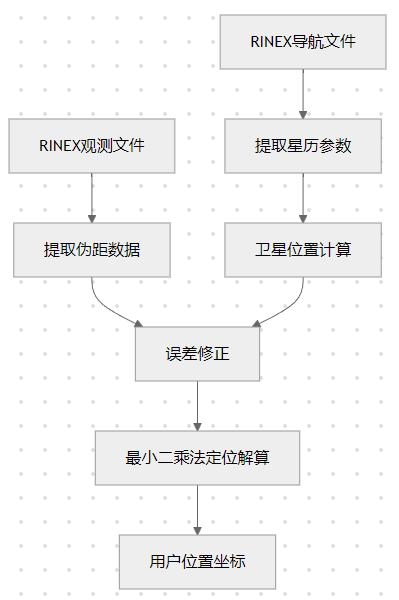
RINEX文件进行卫星导航解算,包括卫星坐标计算和用户位置解算的完整流程。
整体解算流程
RINEX文件结构解析
观测文件格式
c
     3.04           OBSERVATION DATA    M: Mixed            RINEX VERSION / TYPE
teqc  2019Feb25     NOAA/NOS/NGS/CORS   20240429 06:34:24UTCPGM / RUN BY / DATE
                                                            MARKER NAME
                                                            MARKER NUMBER
                                                            OBSERVER / AGENCY
                                                            REC # / TYPE / VERS
                                                            ANT # / TYPE
     -2162989.6650   -4487349.1120    3838429.4097                  APPROX POSITION XYZ
          0.0000          0.0000          0.0000                  ANTENNA: DELTA H/E/N
     1    1                                                      WAVELENGTH FACT L1/2
     6    C1    L1    L2    P1    P2    S1                       TYPES OF OBSERV
导航文件格式
c
     3.04           NAVIGATION DATA     M: Mixed            RINEX VERSION / TYPE
teqc  2019Feb25     NOAA/NOS/NGS/CORS   20240429 06:34:24UTCPGM / RUN BY / DATE
                                                            END OF HEADER
 1 24  4 28  6 34 24.0 0.110304355756D-03 0.000000000000D+00 0.000000000000D+00
    0.700000000000D+01 0.206250000000D+02 0.465377655669D-08 0.290441894374D+01
    0.115018337965D-05 0.144875647966D-01 0.119209289551D-04 0.515365028381D+04
    0.388800000000D+06 0.111758708954D-06 0.000000000000D+00 0.000000000000D+00
    0.112000000000D+04 0.000000000000D+00 0.512227416039D-08 0.700000000000D+01
    0.214890000000D+06 0.000000000000D+00 0.000000000000D+00 0.000000000000D+00
MATLAB实现代码
1. RINEX文件读取
matlab
function [obs_data, header] = read_rinex_obs(filename)
    % 读取RINEX观测文件
    fid = fopen(filename, 'r');
    if fid == -1
        error('无法打开文件: %s', filename);
    end

    % 读取文件头
    header = struct();
    while ~feof(fid)
        line = fgetl(fid);
        if contains(line, 'END OF HEADER')
            break;
        end
        % 解析头文件信息...
    end

    % 读取观测数据
    obs_data = struct();
    while ~feof(fid)
        line = fgetl(fid);
        if length(line) < 2
            continue;
        end

        % 解析历元时刻
        if line(1) == '>'
            % 新历元开始
            year = str2double(line(2:5));
            month = str2double(line(7:8));
            day = str2double(line(10:11));
            hour = str2double(line(13:14));
            minute = str2double(line(16:17));
            second = str2double(line(18:29));

            epoch_time = datetime(year, month, day, hour, minute, second);
            obs_data.(datestr(epoch_time, 'yyyymmdd_HHMMSS')) = struct();
            current_epoch = datestr(epoch_time, 'yyyymmdd_HHMMSS');
        else
            % 解析卫星观测数据
            sat_id = strtrim(line(1:3));
            observations = sscanf(line(4:end), '%f');

            % 存储伪距、载波相位等观测值
            if length(observations) >= 1
                obs_data.(current_epoch).(sat_id).C1 = observations(1); % C/A码伪距
            end
        end
    end

    fclose(fid);
end
2. 导航文件读取与星历参数提取
matlab
function eph = read_rinex_nav(filename)
    % 读取RINEX导航文件并提取星历参数
    fid = fopen(filename, 'r');
    if fid == -1
        error('无法打开文件: %s', filename);
    end

    % 跳过文件头
    while ~feof(fid)
        line = fgetl(fid);
        if contains(line, 'END OF HEADER')
            break;
        end
    end

    eph = struct();
    while ~feof(fid)
        % 读取星历数据块
        line1 = fgetl(fid);
        if isempty(line1) || length(line1) < 5
            continue;
        end

        % 解析卫星PRN号和参考时间
        prn = str2double(line1(1:2));
        year = str2double(line1(4:5)) + 2000;
        month = str2double(line1(7:8));
        day = str2double(line1(10:11));
        hour = str2double(line1(13:14));
        minute = str2double(line1(16:17));
        second = str2double(line1(18:22));

        toc = datetime(year, month, day, hour, minute, second);

        % 读取其他星历参数
        line2 = fgetl(fid); line3 = fgetl(fid); line4 = fgetl(fid);
        line5 = fgetl(fid); line6 = fgetl(fid); line7 = fgetl(fid); line8 = fgetl(fid);

        % 解析关键星历参数
        af0 = str2double(line1(23:41));
        af1 = str2double(line1(42:60));
        af2 = str2double(line1(61:79));

        iode = str2double(line2(4:22));
        crs = str2double(line2(23:41));
        delta_n = str2double(line2(42:60));
        m0 = str2double(line2(61:79));

        cuc = str2double(line3(4:22));
        ecc = str2double(line3(23:41));
        cus = str2double(line3(42:60));
        sqrt_a = str2double(line3(61:79));

        toe = str2double(line4(4:22));
        cic = str2double(line4(23:41));
        omega0 = str2double(line4(42:60));
        cis = str2double(line4(61:79));

        i0 = str2double(line5(4:22));
        crc = str2double(line5(23:41));
        omega = str2double(line5(42:60));
        omega_dot = str2double(line5(61:79));

        idot = str2double(line6(4:22));

        % 存储星历数据
        eph(prn).af0 = af0;
        eph(prn).af1 = af1;
        eph(prn).af2 = af2;
        eph(prn).iode = iode;
        eph(prn).crs = crs;
        eph(prn).delta_n = delta_n;
        eph(prn).m0 = m0;
        eph(prn).cuc = cuc;
        eph(prn).ecc = ecc;
        eph(prn).cus = cus;
        eph(prn).sqrt_a = sqrt_a;
        eph(prn).toe = toe;
        eph(prn).cic = cic;
        eph(prn).omega0 = omega0;
        eph(prn).cis = cis;
        eph(prn).i0 = i0;
        eph(prn).crc = crc;
        eph(prn).omega = omega;
        eph(prn).omega_dot = omega_dot;
        eph(prn).idot = idot;
        eph(prn).toc = toc;
    end

    fclose(fid);
end
3. 卫星位置计算
matlab
function [sat_pos, sat_clock_corr] = calculate_satellite_position(eph, prn, transmit_time)
    % 根据星历参数计算卫星在ECEF坐标系中的位置
    % 输入:eph - 星历数据,prn - 卫星号,transmit_time - 信号发射时间

    % GPS系统常量
    GM = 3.986005e14;             % 地球引力常数 (m^3/s^2)
    omega_e_dot = 7.2921151467e-5; % 地球自转角速度 (rad/s)

    % 提取该卫星的星历参数
    af0 = eph(prn).af0;
    af1 = eph(prn).af1;
    af2 = eph(prn).af2;
    sqrt_a = eph(prn).sqrt_a;
    delta_n = eph(prn).delta_n;
    m0 = eph(prn).m0;
    ecc = eph(prn).ecc;
    omega = eph(prn).omega;
    cuc = eph(prn).cuc;
    cus = eph(prn).cus;
    crc = eph(prn).crc;
    crs = eph(prn).crs;
    cic = eph(prn).cic;
    cis = eph(prn).cis;
    i0 = eph(prn).i0;
    idot = eph(prn).idot;
    omega0 = eph(prn).omega0;
    omega_dot = eph(prn).omega_dot;
    toe = eph(prn).toe;

    % 1. 计算信号传播时间tk (从参考时间toe开始)
    tk = transmit_time - toe;

    % 2. 卫星时钟修正
    sat_clock_corr = af0 + af1 * tk + af2 * tk^2;

    % 3. 校正后的发射时间
    t = transmit_time - sat_clock_corr;
    tk = t - toe;

    % 4. 计算平近点角
    a = sqrt_a^2;  % 轨道长半轴
    n0 = sqrt(GM / a^3);  % 计算平均角速度
    n = n0 + delta_n;     % 校正后的平均角速度
    mk = m0 + n * tk;     % 平近点角

    % 5. 解开普勒方程求偏近点角
    ek = mk;
    for iter = 1:10  % 迭代求解
        ek_new = mk + ecc * sin(ek);
        if abs(ek_new - ek) < 1e-12
            break;
        end
        ek = ek_new;
    end

    % 6. 计算真近点角
    vk = atan2(sqrt(1 - ecc^2) * sin(ek), cos(ek) - ecc);

    % 7. 计算升交距角
    phik = vk + omega;

    % 8. 计算二阶调和修正
    delta_uk = cus * sin(2 * phik) + cuc * cos(2 * phik);  % 纬度幅角修正
    delta_rk = crs * sin(2 * phik) + crc * cos(2 * phik);  % 向径修正
    delta_ik = cis * sin(2 * phik) + cic * cos(2 * phik);  % 轨道倾角修正

    % 9. 计算修正后的轨道参数
    uk = phik + delta_uk;          % 修正后的纬度幅角
    rk = a * (1 - ecc * cos(ek)) + delta_rk;  % 修正后的向径
    ik = i0 + idot * tk + delta_ik; % 修正后的轨道倾角

    % 10. 计算卫星在轨道平面内的位置
    xk_orb = rk * cos(uk);
    yk_orb = rk * sin(uk);

    % 11. 计算升交点经度
    omega_k = omega0 + (omega_dot - omega_e_dot) * tk - omega_e_dot * toe;

    % 12. 计算地固坐标系中的卫星位置
    xk = xk_orb * cos(omega_k) - yk_orb * cos(ik) * sin(omega_k);
    yk = xk_orb * sin(omega_k) + yk_orb * cos(ik) * cos(omega_k);
    zk = yk_orb * sin(ik);

    sat_pos = [xk; yk; zk];
end
4. 伪距定位解算
matlab
function [pos, clock_bias, dop, residuals] = pseudorange_positioning(obs_data, eph, epoch_time, initial_pos)
    % 使用伪距测量法解算用户位置
    % 输入:观测数据,星历数据,历元时间,初始位置估计

    % 提取该历元的观测数据
    epoch_str = datestr(epoch_time, 'yyyymmdd_HHMMSS');
    if ~isfield(obs_data, epoch_str)
        error('该历元无观测数据');
    end

    current_obs = obs_data.(epoch_str);
    satellites = fieldnames(current_obs);

    % 初始化
    num_sats = length(satellites);
    if num_sats < 4
        error('可见卫星数不足4颗,无法定位');
    end

    % 光速 (m/s)
    c = 299792458;

    % 初始估计
    x = [initial_pos; 0];  % [X; Y; Z; 接收机钟差]

    % 迭代求解
    max_iter = 10;
    tolerance = 1e-6;

    for iter = 1:max_iter
        H = zeros(num_sats, 4);  % 设计矩阵
        w = zeros(num_sats, 1);  % 残差向量
        predicted_ranges = zeros(num_sats, 1);

        for i = 1:num_sats
            sat_id = satellites{i};
            prn = str2double(sat_id(2:3));  % 提取卫星PRN号

            % 获取伪距观测值
            if isfield(current_obs.(sat_id), 'C1')
                pseudorange = current_obs.(sat_id).C1;
            else
                continue;
            end

            % 计算信号发射时间 (考虑卫星钟差和传播时间近似)
            transmit_time = epoch_time - pseudorange / c;

            % 计算卫星位置和卫星钟差
            [sat_pos, sat_clock_corr] = calculate_satellite_position(eph, prn, transmit_time);

            % 计算几何距离
            geometric_range = norm(sat_pos - x(1:3));

            % 预测的伪距 (包含接收机钟差)
            predicted_ranges(i) = geometric_range + x(4) * c - sat_clock_corr * c;

            % 计算视线向量 (单位向量)
            line_of_sight = (sat_pos - x(1:3)) / geometric_range;

            % 构建设计矩阵
            H(i, 1:3) = -line_of_sight;
            H(i, 4) = 1;

            % 计算残差
            w(i) = pseudorange - predicted_ranges(i);
        end

        % 最小二乘解
        dx = (H' * H) \ (H' * w);

        % 更新估计
        x = x + dx;

        % 检查收敛
        if norm(dx) < tolerance
            break;
        end
    end

    % 输出结果
    pos = x(1:3);
    clock_bias = x(4);

    % 计算DOP值
    Q = inv(H' * H);
    dop.gdop = sqrt(trace(Q));
    dop.pdop = sqrt(trace(Q(1:3, 1:3)));
    dop.hdop = sqrt(Q(1,1) + Q(2,2));
    dop.vdop = sqrt(Q(3,3));
    dop.tdop = sqrt(Q(4,4));

    % 计算残差
    residuals = w;
end
5. 完整的主程序
matlab
function main_gnss_solver()
    % 主程序:GNSS定位解算

    % 文件路径
    obs_file = 'example.obs';  % RINEX观测文件
    nav_file = 'example.nav';  % RINEX导航文件

    % 读取RINEX文件
    fprintf('读取RINEX文件...\n');
    [obs_data, obs_header] = read_rinex_obs(obs_file);
    eph = read_rinex_nav(nav_file);

    % 从观测文件头获取近似坐标
    if isfield(obs_header, 'APPROX_POSITION')
        initial_pos = obs_header.APPROX_POSITION;
    else
        % 如果没有近似坐标,使用地球中心作为初始估计
        initial_pos = [0; 0; 0];
    end

    % 选择要处理的历元
    epoch_fields = fieldnames(obs_data);
    first_epoch = datetime(epoch_fields{1}, 'InputFormat', 'yyyyMMdd_HHmmss');

    fprintf('处理历元: %s\n', datestr(first_epoch));

    % 执行定位解算
    [pos, clock_bias, dop, residuals] = pseudorange_positioning(...
        obs_data, eph, first_epoch, initial_pos);

    % 坐标转换 (ECEF到经纬高)
    [lat, lon, height] = ecef2llh(pos);

    % 显示结果
    fprintf('\n=== 定位结果 ===\n');
    fprintf('ECEF坐标: X=%.3f m, Y=%.3f m, Z=%.3f m\n', pos);
    fprintf('经纬高: 纬度=%.6f°, 经度=%.6f°, 高程=%.3f m\n', ...
        lat, lon, height);
    fprintf('接收机钟差: %.3f m (%.9f s)\n', clock_bias, clock_bias/299792458);
    fprintf('\n=== DOP值 ===\n');
    fprintf('GDOP: %.3f\n', dop.gdop);
    fprintf('PDOP: %.3f\n', dop.pdop);
    fprintf('HDOP: %.3f\n', dop.hdop);
    fprintf('VDOP: %.3f\n', dop.vdop);
    fprintf('TDOP: %.3f\n', dop.tdop);

    % 残差分析
    fprintf('\n=== 残差分析 ===\n');
    fprintf('RMS残差: %.3f m\n', rms(residuals));
    fprintf('最大残差: %.3f m\n', max(abs(residuals)));
end

function [lat, lon, height] = ecef2llh(xyz)
    % ECEF坐标转经纬高
    x = xyz(1); y = xyz(2); z = xyz(3);

    % WGS84椭球参数
    a = 6378137.0;           % 长半轴
    f = 1/298.257223563;     % 扁率
    e2 = 2*f - f^2;          % 第一偏心率平方

    % 计算经度
    lon = atan2(y, x);

    % 迭代计算纬度和高程
    p = sqrt(x^2 + y^2);
    lat = atan2(z, p * (1 - e2));

    for i = 1:10
        N = a / sqrt(1 - e2 * sin(lat)^2);
        height = p / cos(lat) - N;
        lat_new = atan2(z, p * (1 - e2 * N / (N + height)));

        if abs(lat_new - lat) < 1e-15
            break;
        end
        lat = lat_new;
    end

    % 转换为度
    lat = rad2deg(lat);
    lon = rad2deg(lon);
end
参考代码 卫星导航解算 www.3dddown.com/csa/64134.html
关键技术与误差处理
主要误差源及修正
matlab
function corrected_pseudorange = apply_error_corrections(raw_pr, sat_pos, rec_pos, eph, time)
    % 应用各种误差修正

    % 1. 卫星钟差修正 (已在卫星位置计算中处理)

    % 2. 电离层延迟修正 (Klobuchar模型)
    iono_delay = klobuchar_correction(rec_pos, sat_pos, time);

    % 3. 对流层延迟修正
    tropo_delay = hopfield_correction(rec_pos, sat_pos);

    % 4. 地球自转修正 (Sagnac效应)
    sagnac_corr = sagnac_correction(sat_pos, rec_pos);

    corrected_pseudorange = raw_pr - iono_delay - tropo_delay + sagnac_corr;
end

function iono_delay = klobuchar_correction(rec_pos, sat_pos, time)
    % Klobuchar电离层模型
    % 简化实现 - 实际应用需要电离层参数
    elevation = calculate_elevation(rec_pos, sat_pos);
    iono_delay = 5.0 / sin(elevation + 0.1);  % 简化模型
end

function tropo_delay = hopfield_correction(rec_pos, sat_pos)
    % Hopfield对流层模型
    elevation = calculate_elevation(rec_pos, sat_pos);
    tropo_delay = 2.3 / sin(elevation);  % 简化模型
end
建议
- 数据质量检查:处理前先检查数据完整性和质量
- 多历元平滑:使用多个历元数据进行平滑提高精度
- 多系统融合:结合GPS、GLONASS、Galileo等多系统数据
- 精密星历:如需更高精度,可使用精密星历替代广播星历