- 关键数据集分类:地表参数数据集
- 空间分辨率:km
- 共享方式:开放获取
- 数据大小:1.41 GB
- 数据时间范围:1980s
- 元数据更新时间:2021-04-19
数据集摘要
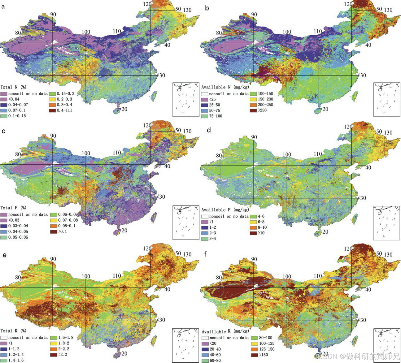
数据集包括以下土壤理化性质:pH值、有机质含量、阳离子交换量、根系丰度、总氮(N)、总磷(P)、总钾(K)、碱解氮、速效磷、速效钾、可交换H+、Al3+、Ca2+、Mg2+、K+、Na+、土层厚度、土壤剖面深度、砂、淤泥和C。铺设部分、岩石碎片、体积密度、孔隙、结构、稠度和土壤颜色。提供了质量控制信息(QC)。 分辨率为30弧秒(赤道处约1公里)。土壤性质的垂直变化由8层记录,深度为2.3 m(即0-0.045-0.091、0.091-0.166、0.166-0.289、0.289-0.493、0.493-0.829、0.829-1.383和1.383-2.296 m),以便于在普通土地模型和社区土地模型(CLM)中使用。
 图片来源于网络,仅供参考
数据采用NetCDF格式存储,数据文件名称及其说明如下: 1.THSCH.nc: Saturated water content of FCH 2.PSI_S.nc: Saturated capillary potential of FCH 3.LAMBDA.nc: Pore size distribution index of FCH 4.K_SCH.nc: Saturate hydraulic conductivity of FCH 5.THR.nc: Residual moisture content of FGM 6.THSGM.nc: Saturated water content of FGM 7.ALPHA.nc: The inverse of the air-entry value of FGM 8.N.nc: The shape parameter of FGM 9.L.nc: The pore-connectivity parameter of FGM 10.K_SVG.nc: Saturated hydraulic conductivity of FGM 11.TH33.nc: Water content at -33 kPa of suction pressure, or field capacity 12.TH1500.nc: Water content at -1500 kPa of suction pressure, or permanent wilting point
数据文件命名方式和使用方法
NC栅格文件 可以用Arcgis、Qgis等遥感软件及程序打开
数据要求的引用方式
戴永久, 上官微. (2019). 中国土壤有机质数据集. 国家青藏高原科学数据中心. https://doi.org/10.11888/Soil.tpdc.270281. https://cstr.cn/18406.11.Soil.tpdc.270281.
Dai, Y., Shangguan, W. (2019). Dataset of soil properties for land surface modeling over China. National Tibetan Plateau / Third Pole Environment Data Center. https://doi.org/10.11888/Soil.tpdc.270281. https://cstr.cn/18406.11.Soil.tpdc.270281.