SuperMap iClient3D for Cesium 如何限制相机位置在边界内
功能介绍
Cesium 中,操作相机时,如果操作不当惠导致相机乱飞,找不到预设的场景,而且Cesium 中也没有可以限制相机的接口,本篇文章通过每帧检测相机位置,实现了将相机限制在了矩形边界内。
效果展示
实现思路
主要实现思路是通过viewer.scene.postUpdate方法注册了一个检测相机位置的方法,每当相机超出了设置的位置就会被强制拉回范围内
设置限制位置
首先设置一个变量确定好相机可以移动的边界位置。
javascript
 // 定义矩形区域 (经度, 纬度)
  const boundary = {
       west: -120,   // 西边界经度
       south: 30,    // 南边界纬度
       east: -100,   // 东边界经度
       north: 50     // 北边界纬度
   };
获取相机位置并且限制经度在边界内
首先通过viewer.camera.position获取相机位置,然后和boundary 进行比较,看是否超出了范围,如果超出了范围就通过viewer.camera.setView将相机拉回范围内。
javascript
  // 相机限制函数
 function constrainCameraToBoundary() {
      const position = viewer.camera.position;
      const cartographicPosition = Cesium.Cartographic.fromCartesian(position);

      // 获取当前相机位置的经纬度
      let longitude = Cesium.Math.toDegrees(cartographicPosition.longitude);
      let latitude = Cesium.Math.toDegrees(cartographicPosition.latitude);
      let height = cartographicPosition.height;
      let heading = viewer.camera.heading;
      let pitch = viewer.camera.pitch;
      let roll = viewer.camera.roll;

      // 限制经度在边界内
      if (longitude < boundary.west) {
          longitude = boundary.west;
      } else if (longitude > boundary.east) {
          longitude = boundary.east;
      }

      // 限制纬度在边界内
      if (latitude < boundary.south) {
          latitude = boundary.south;
      } else if (latitude > boundary.north) {
          latitude = boundary.north;
      }
      // 如果相机超出了边界,将其拉回边界内
      if (longitude !== Cesium.Math.toDegrees(cartographicPosition.longitude) ||
          latitude !== Cesium.Math.toDegrees(cartographicPosition.latitude)) {

          // 保持相机高度不变,只调整水平位置
          const newPosition = Cesium.Cartesian3.fromDegrees(longitude, latitude, height);
          viewer.camera.setView({
              destination: newPosition,
              orientation:{
                    heading:0,
                 		 roll :  6.283185307179586,
                     pitch : viewer.camera.pitch,
              }
            }
          )
      }
  }
注册监听事件
将检测相机位置事件注册到场景每帧更新事件中。只要相机超出范围就被拉回之前的位置。
javascript
 // 注册每帧更新事件
viewer.scene.postUpdate.addEventListener(constrainCameraToBoundary);
完整代码
javascript
<!DOCTYPE html>
<html lang="zh-CN">
<head>
<meta charset="UTF-8">
<meta name="viewport" content="width=device-width, initial-scale=1.0">
<title>Cesium 相机矩形范围限制</title>
<script src="http://support.supermap.com.cn:8090/webgl/Cesium/Build/Cesium/Cesium.js"> </script>
<link href="http://support.supermap.com.cn:8090/webgl/Cesium/Build/Cesium/Widgets/widgets.css" rel="stylesheet">
<style>
body {
margin: 0;
padding: 0;
overflow: hidden;
font-family: Arial, sans-serif;
}
#cesiumContainer {
position: absolute;
width: 100%;
height: 100%;
}
#infoPanel {
position: absolute;
top: 10px;
left: 10px;
background: rgba(0, 0, 0, 0.7);
color: white;
padding: 15px;
border-radius: 5px;
z-index: 100;
max-width: 300px;
}
h1 {
font-size: 18px;
margin-top: 0;
}
.boundary-line {
position: absolute;
pointer-events: none;
}
button {
background: #4CAF50;
border: none;
color: white;
padding: 8px 15px;
text-align: center;
text-decoration: none;
display: inline-block;
font-size: 14px;
margin: 4px 2px;
cursor: pointer;
border-radius: 4px;
}
</style>
</head>
<body>
<div id="cesiumContainer"></div>
<div id="infoPanel">
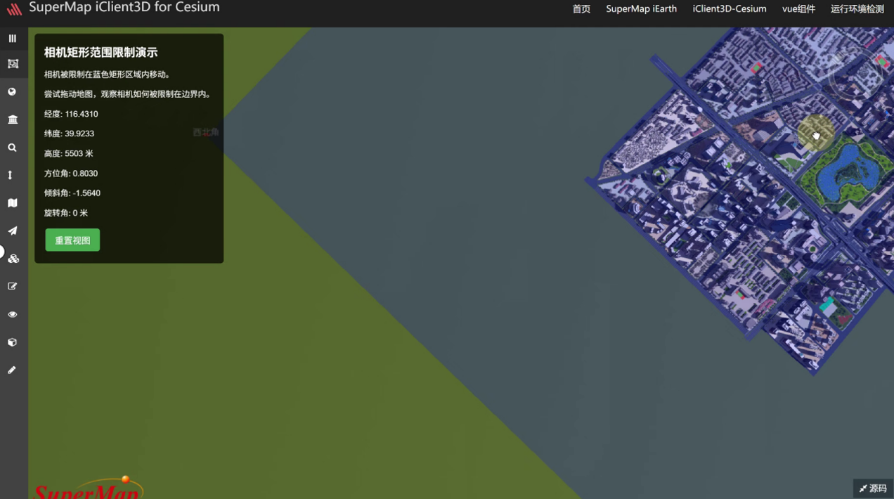
<h1>相机矩形范围限制演示</h1>
<p>相机被限制在蓝色矩形区域内移动。</p>
<p>尝试拖动地图,观察相机如何被限制在边界内。</p>
<div id="coordinates">
<p>经度: <span id="longitude">--</span></p>
<p>纬度: <span id="latitude">--</span></p>
<p>高度: <span id="height">--</span> 米</p>
<p>方位角: <span id="heading">--</span></p>
<p>倾斜角: <span id="pitch">--</span></p>
<p>旋转角: <span id="roll">--</span> 米</p>
</div>
<button id="resetView">重置视图</button>
</div>
<script>
// 初始化Cesium视图
const viewer = new Cesium.Viewer('cesiumContainer', {
terrainProvider: Cesium.createWorldTerrain()
});
// 禁用默认的相机控制限制
viewer.scene.screenSpaceCameraController.enableTranslate = true;
viewer.scene.screenSpaceCameraController.enableLook = true;
viewer.scene.screenSpaceCameraController.enableTilt = true;
viewer.scene.screenSpaceCameraController.enableZoom = true;
// 定义矩形区域 (经度, 纬度)
const boundary = {
west: -120, // 西边界经度
south: 30, // 南边界纬度
east: -100, // 东边界经度
north: 50 // 北边界纬度
};
// 计算矩形中心点
const centerLongitude = (boundary.west + boundary.east) / 2;
const centerLatitude = (boundary.south + boundary.north) / 2;
// 设置初始相机位置到矩形中心
viewer.camera.setView({
destination: Cesium.Cartesian3.fromDegrees(centerLongitude, centerLatitude, 1500000) // 高度设为1500公里
});
// 绘制矩形边界
const boundaryPolygon = viewer.entities.add({
polygon: {
hierarchy: [
new Cesium.Cartesian3.fromDegrees(boundary.west, boundary.south),
new Cesium.Cartesian3.fromDegrees(boundary.east, boundary.south),
new Cesium.Cartesian3.fromDegrees(boundary.east, boundary.north),
new Cesium.Cartesian3.fromDegrees(boundary.west, boundary.north)
],
material: Cesium.Color.BLUE.withAlpha(0.2),
outline: true,
outlineColor: Cesium.Color.BLUE
}
});
// 相机限制函数
function constrainCameraToBoundary() {
const position = viewer.camera.position;
const cartographicPosition = Cesium.Cartographic.fromCartesian(position);
// 获取当前相机位置的经纬度
let longitude = Cesium.Math.toDegrees(cartographicPosition.longitude);
let latitude = Cesium.Math.toDegrees(cartographicPosition.latitude);
let height = cartographicPosition.height;
let heading = viewer.camera.heading;
let pitch = viewer.camera.pitch;
let roll = viewer.camera.roll;
// 更新UI显示
document.getElementById('longitude').textContent = longitude.toFixed(4);
document.getElementById('latitude').textContent = latitude.toFixed(4);
document.getElementById('height').textContent = Math.round(height);
document.getElementById('heading').textContent = heading.toFixed(4);
document.getElementById('pitch').textContent = pitch.toFixed(4);
document.getElementById('roll').textContent = Math.round(roll);
// 限制经度在边界内
if (longitude < boundary.west) {
longitude = boundary.west;
} else if (longitude > boundary.east) {
longitude = boundary.east;
}
// 限制纬度在边界内
if (latitude < boundary.south) {
latitude = boundary.south;
} else if (latitude > boundary.north) {
latitude = boundary.north;
}
// 如果相机超出了边界,将其拉回边界内
if (longitude !== Cesium.Math.toDegrees(cartographicPosition.longitude) ||
latitude !== Cesium.Math.toDegrees(cartographicPosition.latitude)) {
// 保持相机高度不变,只调整水平位置
const newPosition = Cesium.Cartesian3.fromDegrees(longitude, latitude, height);
// viewer.camera.position = newPosition;
// console.log(viewer.camera)
// 保持相机方向不变
// viewer.camera.direction = viewer.camera.direction.clone();
// viewer.camera.up = viewer.camera.up.clone();
// viewer.camera.heading = 0
// viewer.camera.roll = 0
viewer.camera.setView({
destination: newPosition,
orientation:{
heading:0,
roll : 6.283185307179586,
pitch : viewer.camera.pitch,
}
}
)
}
}
// 注册每帧更新事件
viewer.scene.postUpdate.addEventListener(constrainCameraToBoundary);
// 重置视图按钮
document.getElementById('resetView').addEventListener('click', function() {
viewer.camera.setView({
destination: Cesium.Cartesian3.fromDegrees(centerLongitude, centerLatitude, 1500000)
});
});
// 添加一些示例标记以增强可视化
const markers = [
{lon: boundary.west, lat: boundary.south, name: "西南角"},
{lon: boundary.east, lat: boundary.south, name: "东南角"},
{lon: boundary.east, lat: boundary.north, name: "东北角"},
{lon: boundary.west, lat: boundary.north, name: "西北角"}
];
markers.forEach(marker => {
viewer.entities.add({
position: Cesium.Cartesian3.fromDegrees(marker.lon, marker.lat),
point: {
pixelSize: 10,
color: Cesium.Color.RED
},
label: {
text: marker.name,
font: '14px Helvetica',
fillColor: Cesium.Color.WHITE,
horizontalOrigin: Cesium.HorizontalOrigin.CENTER,
verticalOrigin: Cesium.VerticalOrigin.BOTTOM
}
});
});
</script>
</body>
</html>